Name: Google Maps
Subject: Digital Technologies- interactions and impact
Resource Link: https://www.google.com.au/maps/search/maps/@-31.9934583,115.7532729,12z/data=!3m1!4b1
Description:
Google Maps is a sub-program created by Google which enables users to view a map of any mapped area in the world. Commonly used asa navigation tool, the maps allow roads, parks, facilities, and other structures to be viewed in different formats.
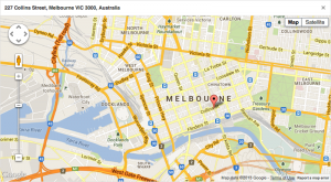
The map function gives the user a basic understanding of where structures and facilities are, whilst focusing on the roads and routes of the area. Main roads are highlighted as yellow, smaller roads and back roads are white, and major highways are a bright orange. All these are on a mostly grey background with only rivers and lakes (blue) and parks and reserves (green) a noticeably different colour. [seen below]
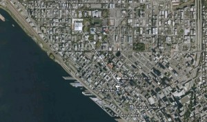
The earth function gives the viewer the same area in a real-life perspective where individual houses, backyards, and structural detail (from bird’s-eye point of view) can be seen as exact as when the picture was taken.
Both functions show suburbs and major street names identified as well as noticeable landmarks and emergency services and entertainment facilities. The program has a zoom tool and an on-the-street visual (street view) tool that gives still pictures of the surrounding street where the tool is placed.

How to use this resource in an educational setting:
This resource, whilst seemingly only relevant to driver’s and adults, is a highly effective tool for teaching. I personally have used this tool several times in a rage of years to give students a varied perspective of their world, allow them control in mapping out journeys and developing their organisation skills, in a mathematical sense referring to scale and efficiency with time/distance knowledge.
In the lower years, once a basic knowledge has been established, this can be a great way of introducing students to their world and beginning discussions regarding building and construction (how did those buildings get there?), planning and design (do you think houses can be built just anywhere?), and redefining the students’ understanding of the world beyond their world.
In the higher years, this resource can be used effectively to assist in mathematical and literacy lessons where students explore a realistic representation of their surroundings. I have personally discovered that at any age, once the student has realised they are looking at a real picture of their (or someone else city) they become very interested and engaged with the learning.
Finally this resource can be used to foster independence, especially in the higher years (5 and 6) where students may have to or already be travelling to and from school using public transport. Planning their own excursions and trips, even as a fictional endeavour, can lead to a unique appreciation for the responsibilities required to master the planning process.
In short, this is a somewhat deceptive resource that can actually be used as a highly interactive and interesting classroom assist!
SCASA links:
Strand– Knowledge and Understanding
Sub– Digital Systems
Digital systems have components with basic functions that may connect together to form networks which transmit data (ACTDIK014)
Strand- Processes and Production Skills
Sub– Digital Implementation
Implement and use simple visual programming environments that include branching (decisions), iteration (repetition) and user input (ACTDIP020)
General Capabilities in ICT:
Literacy
Numeracy
Information Communication Technology (ICT)
Critical and Creative Thinking
Links to Other Learning Areas:
Mathematics
English
HASS- Geography